
Mount Tamborine
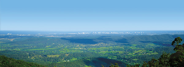
Tamborine Mountain is situated in the border ranges between Queensland and New South Wales. Just over half an hour’s drive from the Gold Coast, and under an hour from Brisbane. A plateau just 8 kilometres long and 4 kilometres wide it had its origins as a’ spit out’ or lava flow from the Mt. Warning volcanic eruption 22 million years ago. Over time, deep gorges, spectacular waterfalls, towering cliffs and wide valleys have been carved into the rocks as rain-fed streams slowly wash away the mountains.
Tamborine Mountain has a cooler climate than the Gold Coast or the city. With its rich, red volcanic topsoil, moistened by an average rainfall of 1550mm (60″), it feeds subsurface streams and basins making it a wonderland for horticulturists. Avocados, grapes, kiwifruit and rhubarb head a long list of commercial crops. There is an immense variety of fauna. Albert lyrebirds, lorikeets, scrub turkeys, bower and whip birds are easily seen. There are platypus in the hidden streams and glow-worms clearly visible at dusk in the rainforest caves. The variety of flora ranges from Australian natives and semi-tropical to the gentle flora of cooler climates.
Tamborine Mountain, described as a “rainforest oasis”, had its beginnings when early settlers had the foresight to seek declaration of a national park at Witches Falls, declared in 1908. Witches Falls was Queensland’s first national park providing refreshing sub-tropical rainforest walks with numerous accessible waterfalls. Over the years additional reserves have been declared and today the park is made up of 12 sections of land on Tamborine plateau and its surrounding foothills.
Bush Walking Tracks
Most walking tracks are short and can be walked within a few hours. The walks are relatively easy although some tracks have short steep grades. At usual walking pace, 3km takes about an hour. Time spent bird watching, photographing or walking with young children will extend walking time.
From Joalah
Curtis Falls (1.5km return) – Pass through rainforest and descend steep stairs to a large pool at the base of Curtis Falls. There is an impressive view of the falls and the surrounding columnar basalt rock face.
Joalah Circuit (4.2km) – This track continues down stream from Curtis falls along a palm fringed creek, past cascades to a small pool. Rainforest trees laden with elk horn, stag horn, hare’s foot and birds nest ferns. Look out for Bush Turkeys on this walk.
From The Knoll
Cameron Falls Circuit (3km) – Scenic views, rainforest with large emergent trees, piccabeen groves, transition and open forests. Look out for land mullets and large black skinks, sunning themselves on this track.
From Cedar Creek
Cedar Creek Circuit (3.2km) – Provides access to Cedar Creek and some of it spectacular cascades, waterfalls and rock pools. Pass creek-side plant communities, open and dry rainforests with hoop pines, includes an easy rock hop across the creek.
Rock Scree Walk (1.5km) – Extensive jumbled rock scree slopes feature on this wall through open forest. This track joins the Cedar Creek Circuit where it passes through dry rainforest to the lower falls and returns past the cascades, rock pools and waterfalls.
From Witches Falls
Witches Falls Circuit (3km) – This walk zigzags down the steep mountain side through open forest with banksia trees and into rainforest with huge strangler figs. Pass seasonal lagoons surrounded by piccabeen palm groves and cycad groves before reaching Witches falls.
Beacon Road Track (4km one way) – Descend through rainforest to Witches Falls and continues along the cliff through rainforest with large red cedar trees and eucalypt forest to Beacon Road. From here the Witches Falls car park is 3km via the Beacon and Tamborine Mountain Road.
From MacDonald’s Park
Rainforest Circuit (2.6km) – Pass through rainforests with large strangler figs, piccabeen palm groves and tall trees with vines and ferns. Ideal for birdwatchers and visitors seeking a quiet rainforest walk away from road noise and large numbers of people. Plants along this walking track are named.
From Palm Grove
Palm Grove Circuit (1.4km) – Piccabeen palm groves and rainforest with strangler figs and yellow carabeens feature on this walk.
Curtis Road Track (1.2km one way) – This short walk through rainforest links Palm Groves’ two access roads.
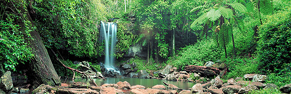
The rainforests include areas with distinctive piccabeen palm groves, wet eucalypt forest dominated by tall flooded gums, strangler figs, cycads, open forest with bracken fern under-storey and woodland. Surrounded by urban and rural development, these plant communities provide essential wildlife habitat. Bird watching is extremely popular the greatest diversity of bird life can be seen early in the morning or late in the afternoon. The area also supports many of the best known native Australian species such as eastern grey kangaroos, numerous wallabies, platypus, echidnas, koalas, lyrebirds and magpies to name a few. Many of the larger mammals such as the kangaroos and wallabies can be seen in the grasslands and open woodlands around the area. Several species are found in the more closed forests and rainforests.
On a historical note, Tamborine Mountain was thrown open for selection in 1875. Applications for blocks of land were granted to nine families. But only two settled on the mountain blocks – John O’Callaghan and his nephew, E.H. O’Callaghan. Another early settler to the north side of the Mountain was Edmond Ford Curtis (Curtis Falls) who moved with his family from the Albert River in 1872.
And the meaning of the word Tamborine?
It has nothing to do with the musical instrument. The Mountain was the home of the Wangerriburra tribe and supplied the Wangerriburra people with a great deal of food. Wangerriburra people used to dig the wild yam, and yams were plentiful at the foot of the Mountain.
History tells us it’s from two Australian aboriginal words – Tam, meaning yam or wild potato and Borine meaning a water place near a cliff. The original site near the village of Tamborine at the base of the mountain is said to be still there.